
This itinerary runs along the upper stretch of the Vinalopó River. In this region where water has been the differentiating feature, we can find a very particular landscape characterized by the existence of riverside ecosystems and crops with greater water needs (hazelnut trees, small vegetable gardens) than strictly dry land (olive and almond trees), in addition to other elements related to water use, such as the irrigation systems of numerous ponds, canals, dams and mills associated with old factories.
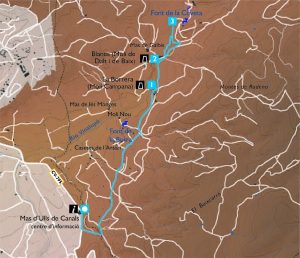
The itinerary begins at the Information Centre of the Natural Park, in Mas d’Ull de Canals. Leaving the farmhouse, follow the forest track that appears on your left and that will lead you almost to the end of the itinerary. Just 500 metres from the start you will cross the Barranc d’Ull de Canalns, where the municipalities of Banyeres de Mariola and Bocairent are bounded.
Continuing along the track, you will find on the left a series of olive and almond tree terraces, and numerous small houses distributed throughout the area known as l’Ansarí. On the right, the vegetation is dominated by pines and bushes; behind us we leave Mas d’Ull de Canals and rise to the bottom, the Penya la Blasca. Before us, the remains of the Vinalopó castle, built on the top of a lonely hill, are increasingly visible, and as we walk we can see the effects of the devastating fire that occurred in 1994 on the surrounding peaks. Following the terraces, now covered with hazelnuts, the presence not too far away of poplars (Populus nigra) occupying a lateral strip, indicates the location of the river bed which, in sections, seems literally dug into the bottom of the valley, towards which we will come closer and closer.
After about 2.5 kilometres from the start, we will reach the vicinity of La Borrera or Molí de la Campana (point 1), with the chimney that we could already glimpse from afar. At the beginning, in 1712, the building was conceived as a flour mill; later, in 1810, it was converted into a paper mill, and finally, between 1855 and 1968, it was transformed into a textile mill. It was a real factory complex, with up to three paper mills (the best known being the Bell Mill, famous for its cigarette paper, one for flour, as well as for spinning). The track continues parallel to the river, decorated with the riverside forest made up mainly of poplars, but also of poplars (Populus alba), willows (Salix sp), brambles (Rubus ulmifolius), rushes, and other species, guarded by the flight of oropendolas (Oriolus oriolus), Nightingales (Luscinia megarhynchos), Scops Owls (Othus scops), Great Tit (Parus major), Myths (Aegithalos caudatus), Bastard Nightingales (Cettia cetti), Robins (Erithacus rubecula), and other small birds that brighten up our walk with their bright colors and songs.
We continue about 300 m upstream until we reach the Blanes factory complex (point 2), also known as the Molí de Baix and the Molí de Dalt. The first buildings, born as flour mills, date from the end of the 18th century. From the beginning of the 19th century until 1942, their destination was the paper industry.
To continue the itinerary we will cross the river and follow a path that runs through the interior of the riverside forest, habitat of an important fauna of which it will not be difficult to find some of the most common species, such as the green frog (Rana perezzi) or the viperine snake (Natrix maura). The old ditch that used to carry water to the numerous mills and rafts that flourished on the river’s edge runs along this bank. We will soon cross the river again to arrive, escorted by kermes oaks, willows and some climbing plants, at the Font de la Coveta (point 3). This is a cavity about 2 m high located in a nook on the right of the path; very close by is a flow meter, which in the past was used to check the water level and regulate it according to stocks and needs.
There is some controversy as to the exact location of the Vinalopó River. Traditionally, the Font de la Coveta has been considered as such, although it is true that the water would come from Els Brulls, or even from an area further upstream, in the vicinity of Mas de Bodí. What is certain is that, it is in this spring where the water springs to the surface permanently, thus creating a true river of life. The waters continue their way, and the riverbed will run through its regions in search of the city of Elche, and disappears before reaching the sea. There are a total of 92 km of scarce flow, since the river has been used since ancient times to move the gears of the textile and paper factories that are so abundant along its course, and also in the irrigated crops that exist on its banks.
To return, we’ll head straight down the forest trail to the factories. Rejecting any fork in the road to the left or right, you will reach the area around Mas d’Ull de Canals again.
Notes: Access with motorized vehicles is not allowed on forest tracks without express authorization; swimming is not allowed in the integral protection area of the source of the Vinalopó river.
The walk starts at the Preventori recreational area (in the municipality of Alcoi), which offers various services such as fountains, rustic tables, bar and toilets, as well as swimming pools in the summer season, all in a place that also offers shaded areas for leisure and relaxation of visitors. This is a very well known and frequented area by the inhabitants of the area. The building was expressly constructed in the 1950s to house a hospital for children suffering from tuberculosis with the economic contributions with which all the city’s social classes and estates participated. Years later it became a home for orphaned children and currently functions as an old people’s home. The path that begins at the height of the large pond and goes into the area where the ravine begins, leads to another part of the area known as L’Horteta del Pobre (point 1), where we will also find stone tables, apart from the pond, the fountain and a new wooden bridge as the protagonist replacing a previous one, all in a fresh corner recently conditioned to welcome the visit of anyone who looks out.
There are many paths that lead to the summit – at 921 metres above sea level, presided over by the cross and the Sant Cristòfol Hermitage (point 2), which gives its name to this public mountain – which have been formed by the movement of many nature lovers who have come here over the years, moving away from the city, to enjoy the peace of the place. Thus, always following the most convenient option to avoid the proliferation of new shortcuts and to reduce the erosion process of the slope, we will ascend this rock hidden by the pines and the most vigorous bushes of a sunny hill like this one. At the beginning the path crosses a soft slope full of pines with the abundant lastón (Brachypodium retusum) and some juniper (Juniperus phoenicea); higher up, pines, rosemary (Rosmarinus officinalis), blackthorns (Rhamnus lycioides subsp. borgiae), male rosemary (Cistus clusii), golden pine (Hypericum ericoides), some aladier (Rhamnus alaternus) and the gorse, cling to the rock by any crack, resisting to lose their chance.
This southern part of the Sierra Mariola has not always had the same appearance, since in the past it had practically no plant cover. The repopulation was carried out as part of the initiative to build a children’s hospital, with the participation of schoolchildren from the entire population and army personnel. During the route we may be surprised by the singing of some birds, the rapid flight of small reptiles and perhaps, with more luck, the majestic flight of the Griffon vulture (Gyps fulvus), a species that has colonized the cliffs of the Barranc del Cint and the surrounding area, the result of a program of reintroduction in the regions of L’Alcoià and El Comtat called Projecte Canyet. The current chapel, renovated a few years ago, is a 20th century building that predates the project of the Preliminary Plan, but it was built on top of a 14th century building that probably had some kind of Muslim construction. It is currently open permanently. Next to the chapel there is a cistern and a large iron cross, visible from a long distance, which was also placed during the 1950s to replace the original wooden one from 1903, which was destroyed during the Civil War.
In many places the initiative was repeated to celebrate the beginning of the new millennium with the placement of crosses on the peaks of elevations well visible from the different towns, although here it was necessary to wait a few years. The excellence of this watchtower as a viewpoint is evident in the wide visual field that is achieved around us. The town of Alcoi, crossed by its rivers and the mountain ranges that close the basin (La Serreta, Els Plans, El Carrascar de la Font Roja and Sant Antoni, …), the outstanding mountains of Almudaina, La Serrella, Aitana and, looking slightly curious, the high coastal spur of Puig Campana. Looking to the north, we will be surprised to see the impressive gorge of the Barranc del Cint and the foothills of Mariola extending eastwards towards Cocentaina and its castle with the Benicadell in the background from this perspective, the Beniarrés reservoir at its feet and the farthest mountains of La Safor; on the other hand, if we look to the west, behind the chapel, the Castellar crag and the fields of Baradello will greet us with their seasonal greenery.
In front, closing the picture towards the interior of the mountain range, the line of the Alt de Les Pedreres and highlighting with a clearer tone, the old craters of mineral extraction that give name to the high, which abandoned this activity years ago, and currently host the commented Projecte Canyet. It should be noted that the entire site, chapel, trails and surroundings, has been conditioned with the anonymous and disinterested effort of many retired residents of Alcoi, lovers of the mountains and that year after year have made this place their home and that of all. The return to the starting point will be done by a path of lesser slope on the northern side of the hill, initially surrounding old olive terraces, and that we will leave before reaching the Baradello de Moia to return to the beginning in a quick and restful descent.