
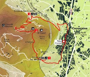
This itinerary begins at the Palau Comtal de Cocentaina, a Gothic-Renaissance building, built on top of an old Muslim building from the 12th century. The Gothic building was built by order of Roger de Llúria, the first feudal lord of the town, in the second half of the 12th century. In the second half of the 15th century, when the Corella family was already a county, they carried out renovation and extension work on the building. This building is of great interest for its artistic and architectural quality, highlighting: the chapel of San Antonio Abad, the Golden Room, the Umbrella Tower and the Ambassadors’ Room; in addition, on the ground floor, a Gothic room has been adapted to house the Municipal Public Library. We start our walk in Plaça del Mercat, looking for the narrow streets of the old Muslim quarter of Raval, which still preserve the charm of a layout of low, crowded houses, a labyrinthine network that gives a very particular character to this part of the town.
We continue along the Carrer del Forn and the church of El Salvador, built on top of the town’s old mosque, until we reach the Creu from where we follow a concrete path that leads directly to Santa Bàrbara. Little by little, the bricks are being replaced by a vegetation made up mainly of Aleppo pine (Pinus halepensis) and a few bushes: heather (Erica multiflora), torvisco (Daphne gnidium) and aladierno (Rhamnus alaternus), scattered among numerous grasses. As we walk, on our right, we can contemplate the majestic castle of Cocentaina, at the top of the hill known as the Penyeta Blanca, serving as a reference point along the entire route.
Finally we reach the entrance that leads us to the recreational area of the Ermita de Santa Bàrbara (point 1). This is a construction of the “conquest” type, tied up in the second half of the 13th century and which gives its name to the recreational area created around it, with benches, a fountain and a children’s playground, all in a place that is very popular with the people of the area, ideal for leisure, and surrounded by a leafy pine forest.
We will continue in the direction we were going, crossing the road to take a path that appears on our right, very close to an electricity tower. This path, protected in certain sections by wooden railings, zigzags along the mountainside to gain the slope without effort. The path links up with a stone path, which runs along the edge of dry crops, mainly olive and almond trees, which are repeated throughout the route, gaining ground on the mountain, in a practice inherited from the Arabs.
The path then forks, avoiding the right-hand branch, which leads to a private property; we continue along the left-hand branch until we find, once again on the left, the start of a path, which we take, entering an area where the vegetation becomes increasingly dense. We find young Aleppo pines and an underbrush made up of heather, rosemary, buckthorn and other bushes. The presence of excrement on or near the path gives us an idea of the existence of certain animals that would otherwise be very difficult to spot, given that they are wild animals that naturally avoid humans: foxes (Vulpes vulpes), field mice (Apodemus sylvaticus), rabbits (Oryctolagus cuniculus), etc. It is easier to observe the flight of certain birds such as the black wheatear (Oenanthe leucura), the kestrel (Falco tinnunculus), the blackcap (Sylvia melanocephala) and the tickereled coot (Parus ater), etc.
The path in this section runs almost parallel to the ravine, and as we ascend, the remains of the ancient wall and the shelters that served as refuge for the ancient inhabitants of these lands, on the slopes of the Penyeta Blanca, become more visible.
We continue to ascend until we reach a small plain, where we find a quince tree (Cydonia oblonga) and a fig tree (Ficus carica), the latter being repeated throughout the route. As we ascend, the presence of the bitter chamomile (Santolina chamaecyparissus), the cat’s tail (Sideritis sp), the runner thistle (Eryngium campestre) and the common broom (Retama sphaerocarpa) becomes more abundant. The path links again with a dirt track, which we will follow in its upward direction to the viewpoint on a plain at the foot of the castle (point 2). This is actually a tower of Christian origin from the end of the 13th or beginning of the 11th century.
It is located on the remains of an old Muslim castle of the Qusantaniya from the 10th century, from the Caliphate period, which would have exercised some military control over the important route of the surrounding lands, offering at the same time refuge for the inhabitants of the nearby farmhouses. It is of Gothic-military style, with ogival elements in arches, doors, windows and interiors. It has a square plan of 13 m side by 12 m high, on a slope of ashlar, to adapt to the irregularities of the land. It has two floors, with several rooms on each floor, an interior patio and a cistern for water supply. Currently restored, it can be accessed by requesting the keys from the Town Hall of Cocentaina. From this viewpoint we can contemplate a magnificent view of the whole valley and the surrounding mountains, from left to right: the Cerincal peak, the entrance to the Quebrantà ravine, with the Port d’Albaida, the Benicadell, the Serra de la Safor, the Beniarrés reservoir, the Serra d’Almudaina, the Serra d’Aitana, the Serreta, the Carrascar de la Font Roja, Els Plans and finally the Pic Negre, like a stone spur, behind which we find Les Penyes Monteses and finally the Montcabrer.
To continue, we will go towards the Pic Negre, with a black colouring on the summit, possible origin of the name, discarding the path on the left closed with a chain. We then take the concrete path on the right and begin the descent; observing the summit from the front, we walk between huts where the native vegetation, hawthorn (Crataegus monogyna), kermes oak (Quercus coccifera), gorse (Ulex sp), buckthorn and cat’s claw (Sedum sediforme), intermingle with ornamental species, giving it an occasionally exotic appearance. We continue between terraces of olive trees (Olea europaea) and almond trees (Prunus amygdalus), with some specimens of fig and pomegranate trees (Punica granatum), discarding any fork in the path until we find a path on the left that goes into a pine forest, which is part of the recreational area of the Chapel of Sant Cristòfol (point 3), continuing along a stone staircase that will lead us to the various services available in the recreational area: paella pans and rustic tables, fountains, children’s playground, bar-restaurant attached to the chapel, erected in the s. This is a wooded area, where pines and acacias (Robinia pseudoacacia) predominate, making it an ideal place for visitors to rest and enjoy.
Leave the car park towards the road, discarding the branch on the left that would lead us, following the so-called “ecological path of the Asquererola” (an old environmental education project that tried to bring some very interesting aspects of the mountain to the users) to Les Huit Piletes. The concrete path on the right would lead us back to the castle. The route continues along the road for 150 metres to continue along an asphalted track on the right. A few metres further on, a hidden path begins on the right and will take us along the edge of the rock to a surprising view of Cocentaina, with the most emblematic buildings and the network of streets that are so different in each of the town’s historic districts, the Raval, with its narrow and irregular streets, the Vila, which is shaped in favour of the main longitudinal streets, and all, of course, with the mountain range that looks to the east and draws the background of this marvellous panorama. Continuing to the left, you go down until you find the first houses of the village and the generous spring of the Pla de la Font, from where you can continue along the streets of the village until you reach the starting point.